


Death Valley Motorcycle Tour
- Tim Mayhew
- Dec 16, 2022
- 12 min read
Updated: Mar 19, 2024

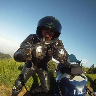
Starting off our 2022 Tour Season, our Death Valley tour begins from Tulare in Central California, at the edge of the Sierra Nevada Foothills. Meeting up with the guys, ready to ride.

Small group this ride, I limited this group to just ten bikes.

Small Central Valley California town of Terra Bella, these are all farming communities

This region east of Tulare was miles and miles of orange trees.

The straights evolve into the rolling hills at the edge of the Sierra Nevada Foothills.

It leads to Fountain Springs. And we continue towards Glennville. We cross over Hot Springs Rd / Parker Pass. We can't take that route this early in the year as there's still too much snow up in the higher elevations.
Next Time: https://www.pashnit.com/ca-hot-springs-rd

Old Stage Rd headed for Posey is a delight. Zero other traffic.
Old Stage Rd also has a mini canyon you ride through - super twisty, and fun!


Zero people out there, we rode the first hour and saw almost no one once in the Sierra Nevada foothills.

Old Stage Rd is a perfect way to start the day.

Near Posey, the group turns south on Jack Ranch Rd to reach Highway 155 - a lower elevation pass to bump over the Southern Sierra Range & reach the Eastern Sierra and on to Death Valley.

Jack Ranch Rd is a rolling county ranch road with zero side roads, traffic is nil.

Near Glennville, we stop to re-group and kick tires. For most of us, this is our first big ride of the year.

Matt & I have ridden a lot together, but job opportunities took him to Texas. He found a Honda ST1300 for $4000 in California, so he flew out to see the bike, bought it, and ride it on this tour, then ride back to Texas. He's keeping one ST1300 in California for these tours, one in Las Vegas for his son, and one in Texas to ride for himself locally.
Yes, he's got three ST1300's.

Reminders. Don't forget.

Phil bought this Aprilia RS660 brand new and set it up for touring. His SV650 with 100k+ miles is his track bike.

Gary is one of my new guys who recently moved to California. While looking for people to ride with and explore his new home, he discovered Pashnit Motorcycle Tours. He first joined us late last year. He loved the tours so much, he signed for every tour I'm offering this season. We'll be seeing a lot of Gary on his GSA.

Break over. Getting back on the road. And you don't see many Kawasaki Z900 RS models out there. Retro Classic.

Glennville

Headed over Highway 155 - Greenhorn Summit

Are there gonna be twisties? Yes. Many.

Wee bit of snow as we climb in elevation up over 6000 ft.

Headed over the 6100-foot Greenhorn Summit

Back down the other side. Highway 155 drops into Wofford Heights along the edge of Lake Isabella.

Into Kernville, and we have to ride around the northern side of the lake. North side has more high speed sweepers.

No longer in the Sierra Nevada, terrain evolves to high desert.


No matter how remote you think you are, there's always road construction somewhere.

Crew was laying fiber optic cable in the middle of nowhere.


This was one of the smart things I bought, enlarging the footprint of my kickstand.

After my unplanned off-road excursions last season, I opted to spend the $18 on a kickstand extender off eBay. It arrives a few days later and made of billet aluminum, attached a few moments later. Makes it easier when riding in sandy environments.

One of the bikes has issues, it's Luc with a bolt backing out. His windscreen is ready to fall off.
One person doing the work, and four supervisors.

Highway 178 has some long desert straights.

And very long downhills coming off the summit on Highway 178.

Not much out here in desert regions but scrub brush.

The ride into Ridgecrest - wide open road


There's a huge military base here in Ridgecrest, Naval Air Weapons Station China Lake, that someday I will check out the military museum there. The base is huge. Its two ranges and main site cover more than 1,100,000 acres, an area larger than the state of Rhode Island.
For now, we stick with the local weird lawn art.

Yes, this is someone's house.


Everybody's talkin' about fuel, but it is what it is. No use complaining about it.


The mining here on the dry lake bed produces 1.7 million tons annually of industrial minerals within the basin to the Searles Valley Minerals mining operations.

White gold - better known as borax.

The mining town of Trona.

Atop the Trona Wildrose Summit looking down on Panamint Valley.
Panamint Valley is the valley to the west of Death Valley. Over the range in these shots is Death Valley.


Strange stuff you find laying out in the middle of the desert.

Desert curves.


More desert curves.


Headed down into Panamint Valley

In Nevada, they've got wild horses that roam, out in the desert they have Wild Burros.

Lot of old history out here


And a lot of long straights. No one to tell you, you can, or you can't.


We made it. Death Valley.


Finally descending into Death Valley.

Riding up and over Town Pass and reaching Stovepipe Wells, our base for the weekend.

Everyone tops off fuel for early departure the next day. We did take bets on what we thought the fuel prices would be at our destination, Stovepipe Wells, out in the middle of the desert. When we arrived, it was less than everyone guessed.
Price of gas at Stovepipe Wells. This was cheap compared to what we would see in Furnace Creek the next day.

The view at Stovepipe Wells

We lucked out on the weather for our weekend ride. Perfect weather in Death Valley. Death Valley hit all-time high temps of 130 degrees in July 2021 and was deemed the hottest place on earth for that particular day at the Furnace Creek Visitor’s Center. For perspective, according to What’s Cooking America, a medium-rare steak is cooked to an internal temperature of 130-135°F.

From Stovepipe Wells, you can clearly see Mesquite Flat Sand Dunes a few miles away. With less than 1% of the entire 3.4 million acres in Death Valley NP featuring dunes, it's a cool microclimate we'll visit on the second day of our ride. While the highest dune is only around 100 feet tall, the entire area makes up the largest concentration of sand dunes in the park.


Desert sunsets

Post-Covid, we're finally allowed sit-down dinners. Last year, everyone had to eat outside.

The interior is covered in movie posters of films all shot in Death Valley.


Mark got pretty excited. He said this was one of the first movies he ever saw in the theater as a kid in 1964.

I retorted that Star Wars was the first movie I ever saw in the theater as a kid in 1977. I was six and my dad took me and my two older brothers in our '72 Ford F150 Pickup to see it, the four of us squeezed onto the bench seat. It was a huge deal as a kid.


I'm Spartacus. No, I'm Spartacus.

Didn't get that?
I guess you had to see the movie. Kirk Douglas. Tony Curtis. Classic.
Closing out a full day's ride.


My wife and I have this odd marriage thing. I text her the menu when I'm traveling, and she texts me back what to order. After 25 years together, she insists she knows what I want better than I do. She might be right.

Day 2: Next day temps are perfect, and the shadows are still long. It's time to ride.


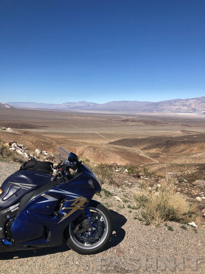
The Hayabusa glows in the morning sun - photographers call this time the Golden Hour.

We all took bets on what gas would be at Stovepipe Wells. It was cheaper than everyone thought.
Everyone tops off when we're in the desert. Even the bike that has the 9-gallon tank. Rules are rules.

See those dunes. We're headed there.

We didn't get far. Three miles down the road is the Mesquite Flats Sand Dunes.


You can often see specks out in the distance. Those are people. We're all geared up, so we don't stay long, enough to experience it, plus early morning temps are still cool.

This location is actually the first Death Valley location you see when watching Star Wars - Episode IV - A New Hope. The scene is early on in the film and comes just after the droids, C-3PO and R2-D2, land on the planet Tatooine.

It's also popular to go sand surfing here. I left my surfboard at home.


Dropping below Sea Level as we ride across the valley.

We had to check out the 20-mule team at the Harmony Borax Works.

Andrew & Phil


We had the place to ourselves.


San Francisco businessman William T. Coleman built this plant in 1882 to refine the "cottonball" borax found on the nearby salt flats. The high cost of transportation made it necessary to refine the borax here rather than carry both borax and waste to the railroad, 165 miles across the desert.


The wagons are huge. Matt for scale.


For more than a century, the 20 Mule Team has been the symbol of the borax industry - on product labels, in history books, and on television. The status is well-earned; mule teams helped solve the most difficult task that faced Death Valley borax operators - getting the product to market. The mule teams pull loads weighing up to 36 tons including 1200 gallons of drinking water. The rear wagon wheels were seven feet high, and the entire unit was more than 100 feet long.

Borates - salt minerals - were deposited in ancient lake beds that uplifted and eroded into the yellow Furnace Creek badlands. Water dissolved the borates and carried them to the Death Valley floor, where they recrystallized as borax.
Borax - blacksmiths used it, as have potters, dairy farmers, housewives, meat packers, and even morticians. For centuries, humans have exploited borax for many important uses.
Chinese laborers recruited from San Francisco scraped borax off the salt flats and carried it by wagon to the refinery. They received $1.30 per day, less lodging and the cost of food they bought at the company store. $1.30 in 1882 is equivalent in purchasing power to about $37.94 today.


Having checked out the Harmony Borax Works, it was time to head for another super cool part of the park, Zabriskie Point

The location was named after Christian Brevoort Zabriskie, vice-president and general manager of the Pacific Coast Borax Company in the early 20th century. The hills are composed of sediments from Furnace Creek Lake, which dried up 5 million years ago—long before Death Valley came into existence.

The earlier reference to the 1960 film Spartacus, Zabriskie Point was used as a film location, showing Gladiator school boss Peter Ustinov on muleback trekking to an Egyptian mine to buy slaves to put in training. In more recent times, shots taken from Zabriskie Point of Red Cathedral and Manly Beacon were used as the basis for shots that were then digitally altered to form the planet of Arvala-7 in the first season of The Mandalorian.

Father-son Matt & Travis came together from El Paso, Texas and Las Vegas, Nevada to meet up and ride together on this tour.

The color in the desert really is stunning.


Snow covered peaks of the Sierra Nevada in the distance.


Leaving Zabriski Point, there's another very cool view nearby that's even better.

The ride up to Dantes's View is steep and curvy.

And has switchbacks

Reaching Dante's View at 5476 ft.

Last year, we were up here one year earlier to the day and encountered very high winds and snow. Peter demonstrates how windy it was. It was so cold up here one year ago, we couldn't stay long.

Fast forward to present day, and temps were perfect, winds were calm.

Snow above 6000 ft on the opposing range.

Dante's View is named from Dante Alighieri, who wrote the Divina Commedia (Divine Comedy), in which there are described the nine circles of Hell, the seven terraces of Purgatory and the nine spheres of Paradise.
In April 1926, some businessmen of the Pacific Coast Borax Company, informed of the touristic attractiveness of Death Valley, were trying to pick the best view of Death Valley. They had nearly chosen Chloride Cliff in the Funeral Mountains when the Deputy Sheriff of Greenwater, Charlie Brown, carried them from this peak a little distance to the Black Mountains. The group was immediately persuaded and promptly called this point Dante's View.

Dante's View was used as a filming location for the 1977 film Star Wars as the characters overlook the fictional Tatooine spaceport of Mos Eisley (which was added into the scene as a matte painting). That view point is Dante's View.

Nobody wanted to hike to the top of the peak. You can.

The highway is far below us on the valley floor over 5000 feet below us.
I pointed out to the group we would be on this road below after lunch.

Phil had never been to Death Valley and was super excited to be here with Pashnit Tours.

Travis

This is Death Valley.

The first time someone suggested we come here for a tour destination, my reaction was, Why? It's a desert. How could that be interesting? But once you're here, you quickly see why they made it a national park. The size, grandeur, and color everywhere leave a lasting impression. You really have to come see it to understand it.

16% Grade on the way down.


Re-grouping. Got everybody? Let's ride.


Rolling into Death Valley Junction


Death Valley Junction has the famous Amargosa Opera House. They just had their Grand Re-opening, and have been operating for 54 years. Tours of the Amargosa Opera House are offered at 9 am and 6 pm daily. We rode by mid-day.

These buildings were constructed in 1923–25 by the Pacific Coast Borax Company. The U-shaped complex of Spanish Colonial Revival architecture style adobe buildings included company offices, employees' headquarters, a dormitory and a 23-room hotel with a dining room, lobby and store.

But we were headed to Shoshone, the next town over for gas & eats.

This is what you get out in the middle of the desert.


Let's all go! & ride the Biggest event of the year.
3rd Annual 1957 Death Valley Motorcycle Run
Road Riders be sure and enter the all highway Flap Jack Road Run
Endurance riders be sure and enter the Jackass Enduro Run
100 Miles of very rough burro trails


I dutifully texted my wife the menu.
She texted back, choose The Club & a root beer.

Sheriff was right next door.


Next door is the town museum. And it was open. Love local museums.
Always stop at the small town museum when traveling.


In the 1930s, a canatelver was added as well as a gas pump and a coat of paint. The two large windows in the front were added also. These gas pumps were called "hand pumps" as the handles were pumped manually as there was no electricity. Note the glass enclosures for supplies between the pumps. Fuel was either "Regular" or "Ethyl."


Mining brought the first white men into the area and the lure of easy riches enticed them to brave the harsh environment in search of that elusive big strike of gold or silver. Those who had explored the region carried out tales of fabulous wealth, and more hardy souls tried their hand at minig.
In fact, mineral resources are abundant in the Southern Amargosa Valley as well as in Death Valley. Silver, gold, lead, copper, zinc, tale, borax, gypsum, and bentonite are just a few of the minerals to be commercially mined in the region.
Gem stone has long been sought by the rock hound, with some success. Amethyst, opal, onyx, turquiose, malachite, chrysocolla, and many types of jasper and agates are found in the hills around Tecopa and Shoshone.
The well known borax is part of the borate family, which consists of about 45 minerals. All contain boron and oxygen in chemical combinations with metals. About four-fifths of them contain water, which cause endless variety in structure. A few samples of borax featured in this museum inclue Colemanite (cyrstal), kernite, ulexite, and cottonball colemanite.


I love this book series. I have a whole bunch of them on my bookshelf. I bought the Nevada Test Site to add to my collection. It sounded interesting..
Awhile back, I bought the Area 51 (far left) book during my 1000-mile day on my Hayabusa riding across Nevada a couple of years ago in Rachel at the Lil Ale'Inn.
I've been to the Hoover Dam on my very first ride across America back in 1993 on my '82 Suzuki GS850L. I had just gotten my motorcycle license a couple of days before the trip.

When my kids were young, always wanted one of these. I throw the kids in the sidecar and off we'd go!


Headed back into Death Valley from Shoshone

Over a low pass, and we drop back into the valley. The elevation continues to drop until we pass below sea level.

A stop at the Ashford Mill Ruins

In 1914, gold ore from the Golden Treasure Mine, 5 miles to the east, was processed here for shipment to a smelter. Legend has t that the Ashford Brothers sold the mine for $50,000 to a Hungarian Count, who later sold it to B.W. Mescausland for $105,000.


Dude, where's my car?


Death Valley is full of long, long straights. But the scenery stretches as far as the eyes can see. From here, we continue dropping in elevation till we're several hundred feet below sea level.


Reaching the Salt Flats at Badwater Basin


Sea level sign everyone takes a picture of


Tradition to walk out onto the salt flats a ways and walk back. Temps are a cool mid-80s here.


Gary

Mark

Halfway up the rock face is the sea level sign. Andrew says okay, far enough, seen it. Done it.


A few miles up the road is Artist's Drive. A single lane road through a small canyon.


Had no intention of fueling up here. It was $6.36 just up the road at Stovepipe Wells. Why it's $2/gallon less 25 miles up the road we'll never know.

But the picture is worth it.

Days end, headed back to base camp.

End of day's ride, time for ice cream


Riding together has a lot of sharing stories.
Phil and I have been riding together on these tours for over ten years.

The end of a good day of riding together looks something like this.

To see the rest of this ride, click here:

Comments