
TOP 10 Reasons


BEAR VALLEY
Sierra Mountain passes
motorcycle tour


Highlights: Newton Rd • Mt Aukum Rd • Ostrom Rd • Hale Rd • Charleston Rd • Volcano • Highway 26 • Ridge Rd • Railroad Flat Rd • Mountain Ranch Rd • Calaveras Cavern • Jesus Maria Rd • Stony Creek Rd • Paloma Rd • Highway 4 Ebbetts Pass • Highway 89 Monitor Pass • Highway 108 Sonora Pass • Highway 4 Ebbetts Pass
Pashnit Tours introduces an all-new tour for 2026 focused on the high sierra mountain regions of eastern California.
What’s the one thing we haven’t done on a Pashnit Tour?
Over the last two decades plus, our tour groups have ridden over 3 million (combined) miles of twisty road, fast roads, s-curve roads, single-lane back roads, and even Valentino’s Rossi’s driveway. We’ve ridden the highest elevation road in California, across wilderness regions of Northern California, up and over mountain peaks, and 136-mile segments of non-stop curves, enjoyed hot tubs overlooking oceans, and raucous loud meals together. We’ve visited 4000-year-old living trees, historic steam trains, explored historic Gold Rush towns, numerous Pacific Coast lighthouses, a historic grist mill, astronomical observatories, a WWII-era relocation camp, sculpture park, a Bigfoot museum, military museums and military airplane museums, climbed to the top of a 6725-ft high granite dome (and looked straight down), rode through sequoia forests, numerous redwood forests, and even petrified forests of 3.4 million-year-old redwoods, active volcanoes, lava tubes, massive waterfalls, the nation’s deepest mountain canyon, and ridden the loneliest road in America together.
But we’ve never been inside a cave. Are there caves in California? Quite a few actually, and several are central to the Sierra Nevada Foothill regions, and… We’ve been riding past them for years.
Sierra Nevada Foothills Cave visit
Pashnit Tours introduces an all new motorcycle tour for the 2026 ride season that includes a visit to a historic cave while basing our tour group at 6600 feet in the Sierra Nevada Mountains.
Captain Joseph Taylor discovered Calaveras Cavern while mining for gold in the Sierra Nevada Foothills—reportedly noticing a breeze moving his paper shooting target during target practice, leading him to discover a hole that led into a vast cavern system during the height of the California Gold Rush of 1849.
The present-day site remains renowned for its two-and‑a‑half miles of interconnected limestone passages, more than any other known cave system in the Mother Lode region.
Taylor initially named it Mammoth Cave, and by 1850 it was recorded as such by map makers of the time. A mining camp grew around the cave on what would become Cave City, due to placer gold found in nearby McKinney Creek, O’Neil Creek, Humbug Creek (later Adobe Gulch), and more.
By 1854, Cave City, near present day Jesus Maria Rd, had one of Calaveras County’s first schools and a population of roughly 400 miners at its peak in 1855.
Placer gold deposits were mostly panned out by 1860, though the town still produced about $20,000 in gold per month; yet, by then, two-thirds of the homes stood vacant as miners moved on to other mining camps.
The cave became a central gathering spot for Cave City, hosting social events like weddings, church services, even town meetings and dances inside rock-hewn chambers. Interior areas of the cave were nicknamed things like “Bishop’s Palace” for the pillar formations resembling a robed bishop.
Visitors were provided a nail to engrave their names on the walls—a tradition that left thousands of signatures, now preserved as part of the cave’s historic character.
By the early 1900s, the cave closed to public tours, and Cave City fell into decline. By the 1950s, no buildings remained in the town but by 1980, the cave was re-opened commercially for cave tours. This Sierra Mountain Range motorcycle tour includes all the usual aspects of our High Sierra Pashnit Tour, endless twisty mountain roads, but will include a stop for a tour of the cave.
Bear Valley Mountain
Originally known as Grizzly Bear Valley, Bear Valley dates to 1855. This narrow bowl-shaped valley sits at the end of the wide two lane elevation climb of Highway 4. Bear Valley Mountain reaches a summit of 8500’, with the base of 6600’. Average snowfall in the area rests at around 30 feet of snow. In the late 1950s, the land was developed, along with Highway 4 into the valley. By 1967, the Skyline Bear Valley mountain resort opened, although the ski runs are all on the backside of the mountain facing north and can’t be seen from the highway. The small ski village community is on the south side of the mountain, facing Highway 4. The ski resort is accessed by taking Mt Reba Rd east of the Bear Valley entrance, which circles around to the backside of the mountain. The ski hill has a broad panoramic view of the Mokelumne River Canyon below Bear Valley Mountain with Mount Reba summit elevation at 8736 ft.
After Bear Valley ski resort survived one of the worst droughts in California history in the early 2010s, the drought ended in massive snowfalls of the 2015-16 winter. Then in 2023, the most snow in 70 years fell on the Sierra Nevada Range. Bear Valley Resort experienced a total seasonal snowfall of 428 inches/35 feet of snow, nearly twice the normal amount. Bear Valley Resort spans 1680 acres and 75 different runs. The trail system around the resort consists of 3000 acres of mountain terrain accessible by the public for cross-country skiing & snowshoeing.
Ride the Sierra Nevada Range
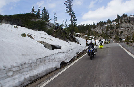
Day 2 involves riding the Sierra Nevada Range over near 10,000 ft mountain passes, Ebbetts Pass and Sonora Pass are right outside our door. Ebbetts Pass, one of the Sierra's highest mountain passes at nearly 10,000 ft, welcomes you twisting up and over the range.
There's much to see, and a thrilling vista is at every turn. There will be plenty of time to take in the sights, shoot some pics, and enjoy the ride. Ebbetts Pass actually has two summits with a saddle like depression in the middle. This is the Sierra Nevada at its best. The highlight of Highway 4 is a section of road at the crest with no center line, narrow, twisty and incredible vistas! The single-lane section wiggles 24-miles across the Sierra Range from one side to the other past expansive vistas and along the edge of two high mountain lakes, Alpine and Mosquito.
Monitor Pass
Once called the best mountain road in California due to its curves and scenic views by the Destination Highways group, Highway 89 begins to curl up to the summit through several S-curves, climbing steadily without any tight hairpins. The view is tough to not gape at as there are few trees and the view to the west is all snow-capped mountain peaks that reach to nearly 10,000 feet. It’s hard to resist the temptation to stop at every overlook. Sight lines are broad and you can see up the hillside at any approaching traffic as you climb.
Groves of white quaking aspen trees begin to appear as you near the summit. These trees are common at high elevations. These trees have brilliant yellow and orange leaves and are very photogenic with those brilliant colors juxtaposed against their white trunks during our fall ride season.
Two S curves through the aspen grove and Monitor Pass peaks over a ridge into a short bowl straight. It’s the perfect photo spot for pass baggers, those seeking pictures of their bike with the sign at the top of every mountain pass.
One of the most photogenic spots in all of the Sierra Nevada Range is here: a broad depression known as Slinkards Valley presents itself with Slinkard Creek running right down the middle of the valley. Mountain ridge tops surround this valley.
The descent off Monitor summit is pure joy, motorcycling at its best. Describe the perfect riding experience? This is it. Look no further. Perfect pavement, endless curve, impressive views, unencumbered views spanning across mountain tops. Ride it fast, ride it slow, makes no difference. Descend off this broad viewpoint curving downhill through two switchbacks and then a series of easy does it S-curves. Numerous options present us on the east side of the range, Walker, Virginia Lakes, Twin Lakes, Bodie Ghost Town. Every ride is a different destination.
Sonora Pass
A few miles south of Ebbetts Pass, we'll make for Sonora Pass in the afternoon, which has even more stunning scenery. The 9624 ft. summit includes a 26% grade and aggressive switchbacks.
There are very few roads anywhere this steep, and the smell of brakes is everywhere. During the month of June, there will be ample amounts of snow in the mountains and all the peaks will be covered in a layer of white. Some of our tour seasons included 10 feet of snow on either side of the road as we ride over the summit.
After descending out of the Sierra Nevada, we'll head back up the mountain to Bear Valley Resort and a hearty dinner provided by our host. It's been another weekend of great riding, and this may be some of our alumni’s 2nd or 3rd tour, or 20th tour with us! We'll be looking forward to riding with you again!
quick ride
Tour: June 04, 2027
Meet: 1228 Broadway, Placerville, CA
Arrive: 7:00 AM, Safety Brief 7:30, Depart 8:00 AM
Cost: $490 per rider, $119 Passenger
ROADS:
This tour includes narrow single lane paved mountain roads. The ride includes steep mountain grades to 26% and negotiating tight hair-pin corners. All roads on this tour are paved except three miles of hard pack into Bodie SHP.
EXPERIENCED RIDERS ONLY:
This tour is not recommended for beginner riders or Very Large Motorcycles. Riders are expected to have at least several years of enthusiastic experience on their motorcycle riding remote challenging paved mountain backroads along with at least 5000+ miles of concurrent recent experience.
HIGH DEMAND:
This tour is limited by the amount of rooms at our host lodging. New tours are always very popular with our tour alumni and sell our quickly. We have booked rooms months in advance and our tours sell out by the end of January. Get on our mailing list to be the first to know about new rides. Tours are planned & announced in the late fall of each year.
Book early to ensure a spot on this new ride. Check with us to see if any available spots are open. Some of our rides may have waiting lists to be able to join the group.
MORE DETAILS:
_JPG.jpg)


_JPG.jpg)

.jpg)


Ended
490 US dollars