
TOP 10 Reasons


Forks of Salmon
ride Trinity Alps Wilderness


Highlighted Roads: Highway 299 • Highway 96 • Salmon River Rd • Cecilville Rd • 'The Racetrack' • Gazelle Callahan Rd • Highway 96 • Scott River Rd • Sawyers Bar Rd • Bald Hills Rd
Pashnit Tours introduces an all-new tour for the 2026 tour season focused on the Trinity Alps Wilderness in Northern California, and especially, the Forks of Salmon - both forks. And bonus, now that Bald Hills Rd is paved 100%- we have to ride that too...
The Trinity Alps are a mountain range in Siskiyou and Trinity Counties in far Northern California- mere miles from the Oregon border. A subrange of the Klamath Mountains and located to the northwest of Redding. Our Trinity Alps Wilderness covers 517,000 acres, roughly 800 square miles making it the second largest wilderness area in California.
Now as a motorcyclist, translate that... If you are a rider, it translates like this: It means deserted roads in remote areas that follow rivers, creeks, and stream beds. It means mountain peaks that frame the horizon, roads that carve around peaks, up and over peaks, curves that last for miles gently arcing along rushing rivers that flow into wide valleys of farmland framed by even more mountain peaks.
You have to experience it ... and if you like mountain riding, keep reading...Our destination for this tour is the Trinity Alps.
Picture wilderness. And the further north you ride, the more wild it becomes. Towns get smaller. Distances stretch and the wilderness areas are more vast. Punctuating all that remoteness are several mountains - Mount Shasta being the most prominent - primarily because it lofts 10,000 feet above the flat plain it rests on - visible from nearly 140 miles away. To the east lies the sleepy Mt Lassen, still steaming & simmering from its last eruption a mere 100 years ago in 1917. And to the west... The Trinity Alps. A vast half million acre tract of wilderness with peaks to 9000 ft. This region along the Oregon border is our personal playground.
Trinity Scenic Byway...
Highway 299 offers up a dose of motorcycling at its best. And it does so with a gamete of variety. Much of the ride runs right through the middle of Six Rivers, Trinity, and Shasta National Forests. While Highway 299 is one of the longest signed highways in the state running from the Nevada border clear across the state to the Pacific Ocean, from the motorcyclist’s perspective, we’ll focus on the western half of the state riding Interstate 5 at Redding out to the ocean.
Weaverville oozes tranquil, peaceful, and historic vibes, lacking the tourist feel. The town is named after one of three men who discovered gold here in 1850- they drew lots for the name- and Mr. Weaver won. Very little has changed since then. The same buildings still stand, some are the oldest continually used buildings in the state. The courthouse is the second oldest in California, dating to 1856. The Weaverville Drug Store is the oldest in California, dating to 1852 and is included in the Register of Historic California Businesses. The drug store has been operated by the same family since 1941. Still open. Weaverville downtown is also known for its spiral staircases. There are two, one on each side of Main Street, leading up to 2nd floor balconies that overlook Main Street.
The Joss House, built in 1874, is a Taoist Temple that’s regarded as the best-preserved Gold Rush-era Chinese place of worship. The temple, located in the center of town, is a must-visit. Over 2000 Chinese gold miners lived here in Weaverville in their own Chinatown during the Gold Rush.
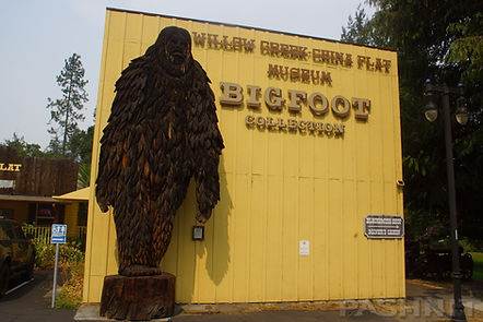
Willow Creek...
Finally reaching Willow Creek an hour after leaving Weaverville, top off our fuel and check out the Bigfoot Museum in town. While the museum includes static displays of equipment outside including a 14-ft tall chainsaw carving of the elusive creature, inside a separate room is designated solely for Bigfoot memorabilia. From board games, books and assorted plaster casts of footprints the elusive creature has left behind, the museum is a worthy stop for those not familiar with the Bigfoot lore of Northern California.
Willow Creek is small, but the largest town for a 30-mile radius. The junction of Highway 299 and Highway 96 is here. Combined with 299, Highway 96 makes a complete loop and jettisons you at Yreka near the Oregon border. Access to Bald Hills Rd via Hwy 169 at Weitchpec is the only road that connects to anything along Highway 96 other than the Forks of Salmon and Happy Camp Rd.
Highway 96...
Highway 96 is one of the longest river roads in the state, spanning over 150 miles of non-stop curves, it hugs the banks of the mighty Klamath River across a very sparely populated region of the state curving around the Marble Mountain Wilderness. Originating in Oregon and at a total length of 257 miles, the Klamath River drains 16,000 square miles. It's one of the few rivers that flows towards the mountains, rather that out.
Plans were proposed in the 1950s to reverse the flow of the Klamath River and send the water via a tunnel under the mountains into the Sacramento Valley and on to Los Angeles. Thankfully that idea never gained much traction and we're left with a motorcycling destination unlike any other in the state. We’ll use Highway 96 & Scott River Rd to skip north through a fun set of curves to reach Somes Bar and the Forks of Salmon.
Forks of Salmon to Cecilville...
For all the talk of narrow single lane stretches the Forks of Salmon is famous for, this is not that place. The first 7 miles (on the eastern side) are two lanes with a center line with fair pavement through numerous s-curves, inviting frivolity and glee. Rapids along the Salmon River call out to kayakers, and you may see people in wet suits preparing for the cold mountain water at numerous river access points. Numerous side roads spider away from the river with names like Brannon’s Bar, Oak Bottom & Three Dollar Bar. Otter Bar Lodge is a small resort along the river that caters to kayakers.
Over a million ounces of gold was removed from the Salmon River Valley, worth over $1B in today’s dollars, yes, with a B. The Salmon River quickly became the richest gold-producing region in Siskiyou County.
The next 10 miles to Forks of Salmon is all single lane. Wandering along the river through tree tunnels and sometimes along sheer rock cliffs. The drop-offs begin here and, at first, are a bit unnerving. There are few guard rails anywhere and at the right spot, you can see straight down into the river below.
In several sections, the cliff edge into the canyon is frequently inches away, with zero shoulders along the stretch into Forks of Salmon. One might assume this is a temporary thing, but on the contrary, this single-lane goes for miles and continues on both forks, but is most pronounced on the Cecilville Rd portion. It’s also the highlight of the ride. Moss clings to the rock face along the road, providing an aura of greenery in spring months, but the opposite is also true in late summer, when these canyons are layered in stagnant hot air with nowhere to go. Riding in 90 degree temps in the heart of summer would not be unusual.
There are stretches of the one-lane section into Forks of Salmon that have an ethereal quality to them. As in, this can’t be real. I’m on a single lane rural remote mountain road in the middle of the wilderness with few people, no towns. The sheer rock walls, the moss, the tree tunnels, the single lane, it’s a unique ride.
Forks of Salmon as the center of this ride dates as far back as one of the earliest mining sites beginning in 1850. The confluence of the two branches of the Salmon River became an important supply center. The flow of miners supported a two-story hotel, bars, and a general store. A sawmill was built at the Forks of Salmon, and another sawmill was built 6 miles upstream at Methodist Creek (at FR 39N04) along the Cecilville Rd portion. By 1858, a post office was established here to service the gold miners. The North Fork of the Salmon River alone produced over 1M troy ounces of gold, at $1500 per ounce at current value, that’s over $1B in gold came out of this valley adjusted for inflation. The Salmon River Valley quickly became one of the biggest gold strikes in American history.
The road from Forks of Salmon to Cecilville (the southern leg of the two forks) was completed in the 1950s. Not much has have changed since then and Cecilville Rd continues the motif of single-lane mountain road with sudden and steep drop-offs. There are numerous places where there are zero shoulders, in addition to a sheer drop-off into the canyon along this single-lane mountain road. Cecilville Rd clings to the contours of the South Fork of the Salmon River along the base of Salmon Ridge to the south. However, Cecilville is at an elevation of 2360’ meaning a steady climb in elevation without any rapid or sudden elevation changes that involve steep climbs or switchbacks.
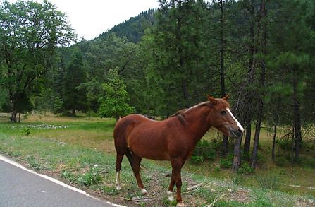
Cecilville marks the halfway point on the Forks of Salmon to Callahan leg of this journey. This tiny mountain community if found on a broad natural flat area nestled in a mountain valley near the junction of the East and South Forks of the Salmon River.
There are no fences in Cecilville and we’ll often find horses standing in the middle of the road. Other times while fueling up our tour group at the above-ground fuel tank, the horses have wandered over out of curiosity, seeking attention and appreciating being stroked and petted.
The section of road from Cecilville to Callahan is the stretch we simply call ‘The Racetrack’. It’s not a race, and it’s not a track, but when you finally ride it, you’ll understand why we call it that. Every motorcyclist has the same reaction every time. What is this doing here? Why was this road built? Can we do that again?
And you would never know this perfect stretch of road exists if someone hadn’t told you about it. We call Northern California a Motorcyclist’s Paradise for a reason, but nowhere is this more evident than right here at The Racetrack. The best part is you’ve ridden by it multiple times and never knew it was there, till now. The Racetrack is one of the most perfectly built, well-engineered motorcycle roads in the state of California. There is zero traffic on it, zero guard rails, zero points of interest, yet the perfect tempo of curves and mountain views. The ride is only 12-miles from Highway 3 to Callahan to the 6100 ft Carter Summit, the highest elevation along this ride, but a total of 30 miles of bliss to reach Callahan where the two-lane meets up with Highway 3. There is no over-hyped drama of xxx Curves in xx Miles, rather The Racetrack flows for 30 miles, it goes and goes, with zero traffic. You’ll lose touch with reality as you flow through the curves one after the other.
Highway 96 times two...
We're going to start second day of touring on Highway 96 - again - a sinuous ribbon of black betrothed and mated to the Klamath River. The river bends, so does the road, the river weaves to & fro, so does the road. If you want to hire the ultimate road design engineer with motorcyclists in mind, hire nature.
The Klamath defines Northern California, flowing 263 miles cutting through the Cascade Range to empty into the Pacific Ocean while draining an extensive watershed of almost 16,000 square miles. It's mountainous terrain. And we'll ride its contours, savoring every moment.
Etna Summit...
The ride from Etna to the Etna Summit is a short but spectacular stretch of pavement. Starting in the quaint town of Etna, the road winds upward through the lush Scott Valley farmland before climbing into the Klamath Mountains. We’ll enjoy sweeping curves, crisp mountain air, and stunning views as the elevation rises toward the 5,900-foot summit while surrounded in snow capped saw tooth peaks..
In spring and early summer, wildflowers line the roadside, while fall offers brilliant foliage. The pavement is generally good, with light traffic if any at all, making it a relaxing yet engaging ride. At the summit, panoramic views reward the climb, offering a perfect photo stop before heading on.
Sawyers Bar...
Sawyers Bar Rd follows the northern leg of the Salmon River through the tiny mountain community of Sawyers Bar, 15 miles away from the Forks of Salmon junction. A road was not built over Etna Summit until the 1892, completed in 1899. Prior to 1899, the gold mining settlement was only reached via walking with your pack animals over the Etna Range to reach Salmon River Canyon until the constant flow of gold miners finally necessitated a crude dirt road.
Gradual improvements over Etna Mountain expanded into an enjoyable two-lane between Etna & the Etna Summit. The climb to the summit is fast, fun, and full of smile-inducing lean angles, climbing from 2940’ to 5950’. The tall snow capped peak directly west is 7044’ Yellow Dog Peak along with a stunning view of the Klamath National Forest.
The region around Sawyers Bar was never improved beyond basic paving and is still single-lane paved road. The first vehicle over the summit was a Ford Model T in 1910, driven over Etna Summit in reverse, since it was the strongest gear. The segment of road from Forks of Salmon to Sawyers Bar was completed around 1937. Not much has changed.
Sawyers Bar Rd still retains the same narrow one-lane motif, with several sections of sheer drop-offs into the river canyon while wiggling left and right. More broad vistas open up in spots, and your brain will surely marvel at the mountain majesty of it all.
A tiny collection of homes labeled as Bestville on some maps signals the entrance into Sawyers Bar. The tiny mountain community of Salmon River was named for Captain Best, who in 1850 led the first party of prospectors into this wilderness area. A small town grew centered around the gold miners at Sawyers Bar. In 1964, an arson fire in Sawyers Bar burned most of the historic buildings in the center of town and they are never rebuilt.
The only business that pops up claiming Sawyers Bar as home is the McBroom & Co. Packers & Guides. In 1847 the McBroom forefathers were the first settlers in the rugged Salmon River canyon. To accommodate the needs of successive settlers, the McBrooms provided a packing service, as in pack animals and mountain trail guides. The packing and guiding tradition goes back six generations, with Dean McBroom serving as the owner, head packer, and guide still in operation nearly 180 years later.
At the Sawyers Bar Town Hall, a plaque placed beside the road reads: Sawyers Bar is perhaps the most picturesque of the northern mining towns. It was founded in 1850 by Captain John Best and party who were guided to the spot by a friendly Indian.The town was originally called Bestville and had over 3,000 inhabitants. It owes its present name to the fact that on an adjacent gravel bar stood the camp of early day mill sawyers. The most noteworthy features are the century old frame buildings and the famous Catholic Church, counterpart of the southern mission.The towns (sic) first postmaster was John Daggett who in 1883 became Lt. Governor of California.
The road becomes progressively narrower as it rides through Sawyers Bar. Sawyers Bar was named in the 1850s for Dan Sawyer, who lived and mined near the site of the present town. Later the name was applied to the settlement recorded on the von Leicht-Craven map of 1874. In the present day, a few houses are still positioned not feet, but mere inches from the single-lane road. The speed limit in town is 15 mph, and that seems entirely appropriate. The population is estimated at 200 people, although that seems optimistic.
Bald Hills Rd...
Scuttlebutt on Bald Hills Rd it is now completely paved. The news sets the mind ablaze. The pavement gods have smiled on us. What was the last 3 miles of gravel has finally been paved in the year 2025. And we can’t resist the chance to be in a position to ride Bald Hills Rd up and over the Coast Range and into Redwood National Park.
The Bald Hills themselves are a long ridge of open grassy highlands mixed with oak woodlands and some redwood groves below the summit, separating the Klamath River drainage on the east (Highway 96) from the Redwood Creek basin (Highway 1) on the west. Bald Hills Rd is one of the most remote northerly curvy motorcycle roads in the state. No towns, no side roads, no people, but endless curve. Bordering the edge of the Redwood National Forest, we’ll have a chance to include redwoods in our tour day. And finish out a day of riding absorbing the majesty of the redwood forest.
And just down the road is our ocean.
quick ride
Tour: May 07, 2027
Meet: 520 Adobe Rd, Red Bluff, CA
Arrive: 7:00 AM, Safety Brief 7:30, Depart 8:00 AM
Cost: $490 per rider, $109 Passenger
ROADS:
This tour includes narrow, steep paved mountain roads. Forks of Salmon includes several lengthy single lane sections. Mountain passes include steep 26% grades and negotiating hairpin corners. All roads on this tour are paved.
EXPERIENCED RIDERS ONLY:
This mountain tour is not recommended for beginner riders or Very Large Motorcycles. Riders are expected to have at least several years of enthusiastic experience on their motorcycle riding remote challenging paved mountain backroads along with at least 5000+ miles of concurrent recent experience.
HIGH DEMAND:
This tour is limited by the amount of rooms at our host lodging. We have booked rooms months in advance and our tours sell out by the end of January. Get on our mailing list to be the first to know about new rides. Tours are planned & announced in the late fall of each year.
Book early to ensure a spot on this new ride. Check with us to see if any available spots are open. Some of our rides may have waiting lists to be able to join the group.
MORE DETAILS:


.jpg)
.jpg)


.jpg)


Ended
490 US dollars