
TOP 10 Reasons


mammoth Yosemite
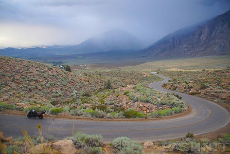
Ride the Volcanic Tableland of the Sierra Nevada

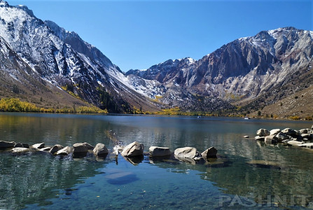
Highlighted Roads: Highway 41 • Glacier Point • The Ahwahnee • Yosemite Valley • Highway 120 Tioga Pass • Mammoth Lakes • Minarets Vista • Devils Postpile NM • June Lake Loop • Mono Lake • Highway 120 • Chalfant Petroglyphs • Lower Rock Creek Rd • Convict Lake • Hot Creek Geologic Site
Pashnit Tours introduces an all-new tour for 2026 focused on the eastern high sierra mountain region known as the Volcanic Tablelands. And yes, Yosemite NP too!
John Muir, a native of Scotland who grew up in Wisconsin, first set eyes on the Yosemite Valley in 1868. “No temple made with hands can compare with Yosemite,” the amateur naturalist wrote. He wasn’t far off. But you have to actually come here to understand what he meant by that observation. Pictures cannot capture the sheer scale, size and grandeur of this place.
Glacier Point...
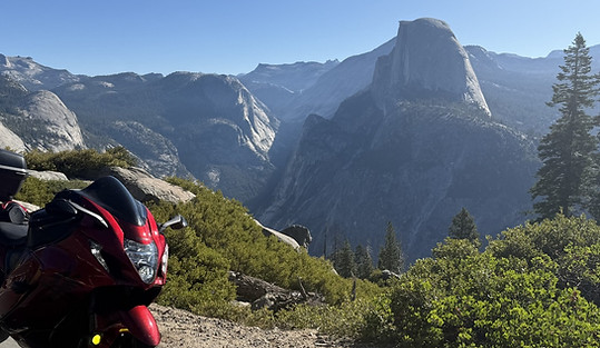
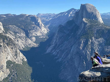
We’ll start our visit to the park with riding straight for Glacier Point at 7200 feet. If you have never visited Yosemite NP, it’s a stunning introduction to the valley as you can walk out to a viewpoint and directly in front of you is Half Dome which peaks at 8839 feet. It seems close enough to touch, and even a minor zoom lens on a camera will allow you to zoom in on people sitting atop Half Dome staring right back at you. A short walk from the first viewpoint, and you’re able to look straight down 3200 feet, higher up than the tallest building in the world, the Burj Khalifa which stands at a mere 2717 ft tall. Glacier Point is like no other viewpoint you’ve been to, it’s also one of the highest natural viewpoints in the United States where you can look straight down over 3000 ft.
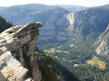
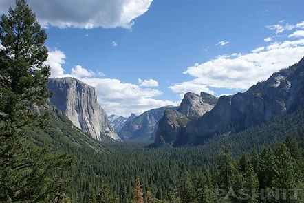
Descending from Glacier Point, we’ll pass through the Wawona Tunnel. At 4,233 feet long, this is the longest highway tunnel in California. Wawona Tunnel was bored through solid granite bedrock and as you exit the tunnel, a broad view of the valley arouses the senses. Tunnel View provides one of the most famous views of Yosemite Valley. The view looks eastward into Yosemite Valley, and includes surrounding features, such as the 3000-ft high southwest face of El Capitan on the left (this makes it a world-famous destination for big wall climbing), Half Dome at center, and Bridalveil Falls on the right. If you have never visited Yosemite NP before, this introduction is quite stunning, enough that a steady stream of tourists pull into a small parking lot to drink in the view.
Yosemite Valley...
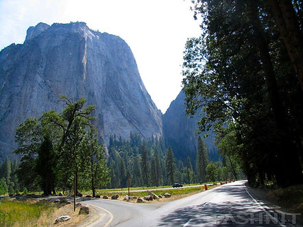
Each time I ride into the Yosemite Valley; I’m amazed we have this in our backyard. The sheer scale of the valley defies your sense of normal space. Walls of granite push straight up 4000 feet from the valley floor, and if you look closely, you can often see tiny specs of color, climbers free climbing their way up the sheer rock walls. Stand at the entrance to the valley at the right time of the year, and you can view waterfalls cascading off granite walls in multiple places. One of which, is one of the tallest waterfalls on the North American continent. Yosemite became America's third national park when Congress set aside over 1500 square miles of land (a region about the size of Rhode Island) under federal jurisdiction with the rest of the park.
For all the vast land area that Yosemite NP covers, the majority of us will simply experience the valley. Ice Age glaciers played an essential role in shaping Yosemite's landscape. The entire valley was once filled with ice. Most of this ice melted away due to natural warming by about 10,000 years ago. What's left is a U-shaped mountain valley. Views abound in every direction, and we’ll need to stop along the way to take a moment to absorb the size and sense of space the valley has. Located at the eastern end of the valley is the Ahwahnee Hotel, this is our midday destination.
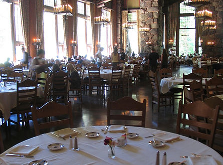
The Ahwahnee Hotel is the crown jewel of national park lodges, the benchmark by which all others are measured. The Ahwahnee was designed and built in the 1920s with the specific goal of attracting well-to-do clientele. In the following century, the Ahwahnee has more than fulfilled that ambition, hosting presidents and royalty as well as other famous personalities within its walls.
Inside the Ahwahnee, the grand fireplace is so large, you can stand inside it. The Ahwahnee Dining Room is a must-see. The 34-foot-high beamed ceilings soar above floor to ceiling windows that showcase the beauty of the surroundings. A meal here with the group is a fitting climax to our morning. But wait, there’s more. We’re not quite done yet.
Tioga Pass...
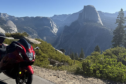
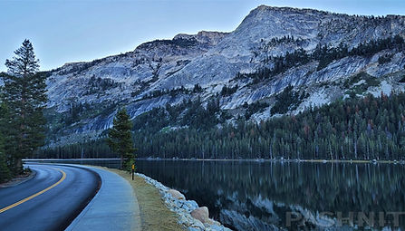
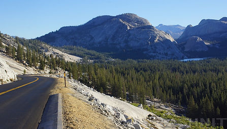
Above Yosemite Valley is Tioga Pass, the highest mountain pass in the state at nearly 10,000 feet. Meandering at first, Tioga Pass builds in a crescendo of visual stimuli, arriving at Olmsted Point at 8418 ft, which provides the perfect visual of the northern side of Half Dome, Clouds Rest, and a view of Tenaya Lake to the east. Half Dome again seems close enough to touch. Olmsted Point was named after famed landscape architects, Frederick Law Olmsted (who was best known for his design of New York's Central Park) and his son, Frederick, Jr. Olmsted was also instrumental in the protection of Yosemite in the 1860s, as he worked with Senator John Conness of California to designate Yosemite Valley and Mariposa Big Tree Sequoia Grove as public lands under the protection of the state.
After leaving Olmsted Point, the visual overload continues with Tenaya Lake & Tuolumne Meadows. Tenaya Lake’s glassy surface mirrors the mountaintops that surround it with an elevation of 8,150 feet. Nearby Tuolumne Meadows pushes off north in brilliant green grasses surrounded in smooth granite rock. At the far end of the meadow is what appears to be a portable tent. This is the local general store and a worthy stop for ice cream.
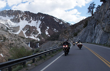
The climb isn’t over, and we need to climb another 2000 feet to reach the top of Tioga Pass at 9945 ft. At nearly 10,000 feet, we finally reach the crest of the Sierra Nevada Range and begin our descent to Mono Lake. The mountains here climb straight up and the road descends quickly dropping 3565 feet in elevation in mere miles finally reaching Lee Vining and Mono Lake.
Mammoth & the Volcanic Tablelands...
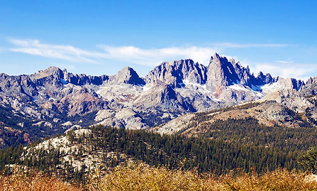
Minaret Vista at 9200 ft starts our day offering one of the most stunning alpine views in the Eastern Sierra. From this easily accessible overlook, we’ll be treated to a breathtaking panorama of the jagged Minarets, Mount Ritter, and Banner Peak—some of the most dramatic peaks in the Sierra Nevada Range. The view from 9200 ft stretches for miles. With its peaceful atmosphere and awe-inspiring scenery, Minaret Vista starts another epic day of riding with the Pashnit crew. Several thousand feet below us is Devils Postpile NM.
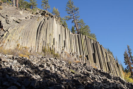
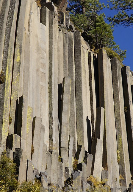
Devils Postpile NM...
Found at the end of a dead-end road, you could ride up & down Highway 395 right by this site for decades and never know it was here. But the rule is- if it's labeled as a National Monument- go see it. Someone was smart enough to protect it for future generations- in this case John Muir among others. Devils Postpile is a geometric rock face made up of columnar basalt pillars 2-3 feet in diameter. The columns are 3, 4, 6, 7 sided - but 5 and 6 stories tall. It's another fascinating slice of California geology.
Would you believe the original plan was to blast away the cliff face to destroy this monument to make way for a hydro-electric dam & flood the valley. The plan was to remove the distinctive basalt columns of Devils Postpile through controlled blasting, leveling the area to create a reservoir basin in the early 1910s. This would have flooded the valley behind the dam, submerging the columnar rock formations and surrounding landscape underwater. Due to public outcry from early conservationists and the growing national interest in protecting unique natural landmarks, the plan to flood the valley was scrapped and Devils Postpile was declared a national monument in 1911.
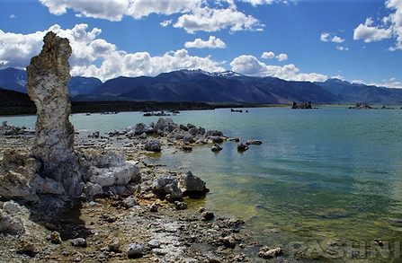
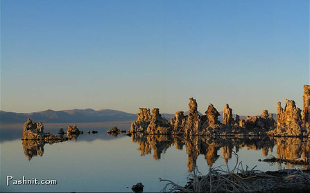
Mono Lake...
Mono Lake is worth a visit if we have the time for its otherworldly beauty and unique natural features. Located east of the Sierra Nevada in California at 6500 ft, this ancient saline lake is one of North America’s oldest, estimated to be over 760,000 years old. Its striking tufa towers—limestone formations created by underwater springs—rise dramatically from the lake’s surface, creating a surreal landscape that feels almost lunar. Reach down & touch the water- it feels like soap due to the high salt content.
Beyond its geology, Mono Lake is a critical habitat for millions of migratory birds, including California gulls and eared grebes, making it a top spot for birdwatchers. The lake’s salty waters support brine shrimp and alkali flies feeding on the salt. The flies cover the beach in a blanket of black - that's moving, which form the base of this vibrant ecosystem.
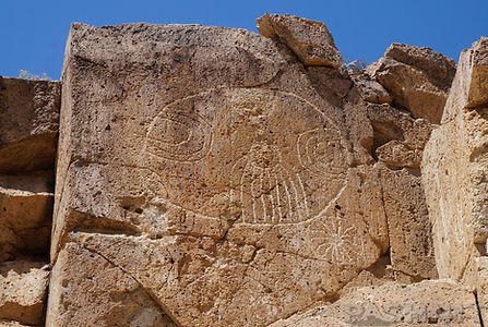
Chalfant Petroglyphs...
But we're not done yet. Ever heard of the Chalfant Petroglyphs? No one has.
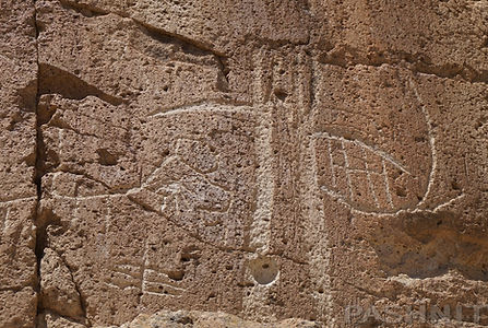
The Chalfant Petroglyphs offer a rare glimpse into the spiritual and artistic expression of Native American cultures, etched into the rugged beauty of California’s volcanic landscape. While the exact creators remain unidentified, these petroglyphs are attributed to Native American groups, particularly the Northern Paiute, who inhabited the region for thousands of years. The carvings are believed to have been created between 500 BC and 1850 AD. Accessible yet remote, they’re a compelling destination for those interested in archaeology, geology, and the deeper history of this region.
Carvings include geometric shapes like concentric circles and spirals (often interpreted as “entoptic patterns”), as well as symbolic figures such as lizards, rattlesnakes, and occasionally anthropomorphic or shamanic imagery. The clusters—particularly the northern and southern ones—are visually striking against the eroded ignimbrite boulders and scenic surroundings.
The Chalfant site contains about 100 petroglyphs. These differ from pictographs as petroglyphs are chipped into the rock rather than painted on. Petroglyphs like these are found throughout the Southwestern Great Basin as far east as Arizona.
Some petroglyphs are recognizable as deer, bighorn sheep, human figures, and birds. Other symbols include lines, grids, and concentric circles in different configurations. When settlers in the late 1800s found these petroglyphs, they carved their own petroglyphs with names and dates as early as 1894 into the rock.
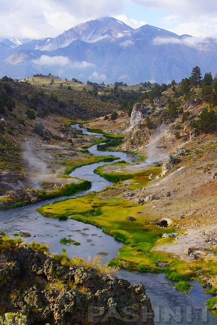
Hot Creek Geologic Site...
Saw this photo at right on the cover of a magazine & wondered, Where is that!? Turns out, I had been riding right past it for 20 years. And, it's right across the road from Mammoth Lakes right behind the Mammoth Airport. Hot Creek is mentioned on a tiny sign along the highway. That’s it and we’ll likely have this amazing site to ourselves.
Hot Creek Geologic Site, easily missed, is right across the highway from Mammoth Lakes, California: The site is a striking natural wonder where geology, geothermal activity, and scenic beauty meet. Set along a stretch of the Owens River, this area features steaming hot springs, boiling pools, and vents that release mineral-rich water directly into the creek. The site sits in the Long Valley Caldera, a massive volcanic depression formed about 760,000 years ago by a supervolcanic eruption. Today, heat from magma still lingering deep underground fuels the area’s geothermal activity.
We'll be able to see plumes of steam rising from turquoise-blue pools, along with colorful mineral deposits staining the surrounding rocks. Temperatures in the water can change suddenly, sometimes reaching boiling. The combination of hot water, river flow, and dramatic Sierra Nevada backdrops creates a unique, photogenic landscape. Hot Creek is also a window into California’s volcanic history, offering insight into the dynamic forces shaping the Eastern Sierra Range.
quick ride
Tour: Sept 18-20, 2026
Meet: 40208 Hwy 41, Oakhurst
Base: Two nights in Mammoth Lakes
Arrive: 7:00 AM, Safety Brief 7:30, Depart 8:00 AM
Cost: $490 per rider, $109 Passenger
ROADS:
This tour includes narrow, steep paved mountain roads. Mountain passes include steep 26% grades and negotiating hairpin corners. All roads on this tour are paved.
EXPERIENCED RIDERS ONLY:
This mountain tour is not recommended for beginner riders or Very Large Motorcycles. Riders are expected to have at least several years of enthusiastic experience on their motorcycle riding remote challenging paved mountain backroads along with at least 5000+ miles of concurrent recent experience.
HIGH DEMAND:
This tour is limited by the amount of rooms at our host lodging. We have booked rooms months in advance and our tours sell out by the end of January. Get on our mailing list to be the first to know about new rides. Tours are planned & announced in the late fall of each year.
Book early to ensure a spot on this new ride. Check with us to see if any available spots are open. Some of our rides may have waiting lists to be able to join the group.
MORE DETAILS:

Starts Sep 18
490 US dollarsLoading availability...
Loading availability...