TOP 10 Reasons


Delta Bodega
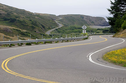
Ever heard of the Montezuma Hills?


Highlighted Roads: Sacramento River Delta • Montezuma Hills Rd • Wooden Valley Rd • Highway 121 • Highway 128 • Butts Canyon Rd • Highway 175 • Stewarts Point Skaggs Spring Rd Hwy 89 • Highway 1 Pacific Coast Hwy • Fairfax-Bolinas Rd • Bolinas Ridge Rd • Sir Francis Drake Blvd
Ever heard of the Montezuma Hills?
No one has. There’s a series of low hills that border the southern edge of the Sacramento River Delta. The delta is a vast expanse of low-lying land spanning 1100 square miles containing the Sierra Nevada mountain run-off.
Sacramento River Delta...
Chinese laborers created the levee system, originally made of peat in the 1850s through 1860s, but subsequent floods wiped out the levees. The levees were built over again, often with clay dredged from the river bottom.
Some homes you’ll see in this region are built up on stilts or raised earthen platforms anticipating possible flooding. Land was reclaimed for agriculture use and over 1000 square miles of farmland was created.
Farm fields are often surrounded 360 degrees by levees creating islands. However, the surface of these fields are lower than the surface of the water surrounding them. Since farm fields are lower than the rivers and sloughs, irrigation is accomplished by releasing water into the fields and saturating the ground, then repeated when irrigation is again required.
Montezuma Hills...
The Montezuma Hills are a hilly region at the southern edge of the Sacramento River Delta. Atop these hills are numerous windmills that tower 260 feet high taking advantage of the Delta Breeze. The Delta Breeze is a natural phenomenon where cool ocean air inflows from the Pacific up a natural corridor along the surface of the low-lying delta towards the Sierra Nevada. The city of Sacramento is in the direct path of these inflows and the Delta Breeze can cool the air significantly in the heat of summer.
Underneath these hills are the largest natural gas field in California, and one of the fifteen largest in the United States. These hills around Rio Vista have produced over 3.6 trillion cubic feet of gas in its lifetime, and is said to contain an estimated reserve of another 330 billion cubic feet of natural gas.
Mayacama Mountains...
Our tour explores the Montezuma Hills and begins heading northwest into the Pacific Coast Range up Wooden Valley and into Napa wine country. Roads are endlessly twisty flowing up low depressions like Pope Valley, Butts Canyon and up and over the Mayacamas Mountains. You’ll likely never notice it from the saddle, but the Mayacamas Mountain Range is home to the world’s largest and most developed geothermal field spanning 22 different power plants spread over 30 square miles. Since 1921, over 350 wells have been sunk into the earth that pull heat from active geothermal vents and convert it to electrical energy.
There are several fun back roads in this region like Geysers Road that border the edge of these active geothermal areas. We’ll also ride by the Old Faithful Geyser of California, an active geothermal geyser that regularly spouts a blast of water every 30-40 minutes year-round.
The geyser produces up to 400 gallons of 350-degree water for a short eruption of about 90 seconds. The water smells like rotten eggs. The heat needed for geyser formation comes from liquid rock or magma when it is near the surface of the earth.
Highway 175...
To get over the Mayacamas Mountains, we have to ride Highway 175 up and over to make our way out to the Pacific Ocean via Walbridge Ridge. No one will ever remember who Walbridge was, rather local riders know Walbridge Ridge better as Skaggs Spring Stewarts Point Rd, a super-fun motorcycle ride paved to perfection with arcing racetrack corners and glorious views across the adjacent hills. But not so fast speed racer, closer to the ocean, the temperatures drop and the road narrows. Skaggs continues to narrow into a single lane as it dives into a redwood forest lush with green.
Once we reach the ocean at Stewarts Point, we get to ride along one of the best and twistiest sections of the Sonoma Coast mere feet from the ocean’s surface. The Sonoma Coast section of Hwy 1 is perfection on two wheels, perfect pavement, jaw dropping views at every corner, and it all leads into Bodega Bay and a room that overlooks the ocean.
Marin County...
Day 2 is an exploration of Marin County, known for Happy Cows and rolling green landscapes. Farmland provides for numerous dairy farms and there may even be a cheese factory in our itinerary. Known for more than happy cows, there must be happy people too. Marin County has the highest life expectancy of any county in the entire United States. Maybe it's the salt air. This county is almost entirely surrounded by water with the ocean to the west, San Francisco Bay to the south, and San Pablo Bay to the east. Bisecting the county north-south is the Coast Range providing endless twisty roads for exploring including one of the most scenic stretches of road in the state, Bolinas Ridge Rd. George Lucas (yes, that George Lucas!) lives here on the Skywalker Ranch along Lucas Valley Road.
But... dear rider, Marin County known for rolling hills and low Coast Range has super-fun motorcycle roads. Our goal is to make a lap of Marin County.
Bolinas Ridge...
Bolinas Ridge is one of our all-time favorite spots within the state of California. This treeless grassy ridgeline overlooking the Pacific Ocean is so extremely scenic, it’s often used for book covers, TV commercials and other forms of promotional media. Winding two lane atop this ridgeline is dreamy goodness for any motorcyclist leading to Mount Tamalpais and then dropping into the seaside town of Sausalito. Two famous lighthouses also line our route to the west, the Point Bonita Lighthouse at the tip of the Marin Headlands, and the Point Reyes Lighthouse.
Marin Headlands...
The Marin Headlands are unique in they produce their own weather when moist, warm Pacific Ocean breezes are pushed up into colder air, creating condensation and fog. While this fog often burns off by mid-day, there have been times we’ve visited the Marin Headlands and been greeted by thick coastal fog.
The Marin Headlands are also best known for many abandoned military installations dating back to the Civil War and extending into the 1960s Cold War. During World War II, Batteries Wallace, Townsley, and 129 on Hawk Hill were dug into the hills to protect San Francisco from aerial bombardment and the high caliber shells that would be fired by Axis battleships that might attack San Francisco Bay. The emplacements at the top of Hawk Hill were used for a radio station. During the Cold War, the gun batteries were decommissioned, but in the 1960s, antiaircraft NIKE missile sites were built on the northern and southern sides of Rodeo Lagoon. Radar sites were placed atop the 920-foot Hawk Hill and Hill 88. At several locations, shelters were built into the hillsides to protect the military personnel from the use of nuclear, biological, or chemical weapons.
One-lane one-way road in the Marin Headlands overlooking the ocean/ The Marin Headlands are one of the most photographed stretches of road in the state due to an unobstructed panorama overlooking the Golden Gate Bridge. A one-lane-one-way narrow road high above the ocean provides a jaw-dropping view of the City of San Francisco. It all leads out to Point Bonita Lighthouse, built in 1855 and currently the only lighthouse in the United States that can only be reached by a suspension bridge. This bridge is 306 feet above the ocean originally built in 1954 after the original path crumbled into the sea. In addition, a 118-foot tunnel was hand carved through the hillside to reach the lighthouse.
After skipping north, we'll ride up into the Golden Gate National Recreation Area which spans 82,027 acres. Our destination is Ridgecrest Road, better known as Bolinas Ridge. Once we reach the top via a twisty convoluted route appropriately called Skyline Drive, the views in all directions are amazing! Especially looking out across Point Reyes and the Pacific Ocean! As we make our way north through pastoral Marin County, you might think you were in another state. Rolling green hills covered in dairy cattle grazing lazily round out the scene. The county is know for 26 different dairy operations, many of them producing organic milk.
We can connect numerous roads in Marin County and come up with a fun backroad trek up through Bodega Bay making northward. Fairfax-Bolinas, Sir Francis Drake, Marshall-Petaluma, Wilson Hill, Bay Hill Rd. We'll be gluing a bunch of these together for the less-traveled path.
Point Reyes Lighthouse...
The Point Reyes National Seashore all leads to a lighthouse 20 miles out into the ocean on the very tip of Point Reyes. The Point Reyes Lighthouse built in 1870 is only reached by walking down (and back up) 300 steps to a rock formation that juts up from the ocean 294 feet. Point Reyes is also the windiest and foggiest place on the Pacific Coast so if we luck out with a sunny day – and we have – we’ll get some amazing photos as we brace for the winds which have seen gales of 75 to 100 mph at this promontory out into the ocean.
Marin County is a rider’s paradise as are most places in California, Redwood Forests, the Pacific Ocean, throw in a taste of the Sacramento Delta and you have yourself a very fun ride, an all new Pashnit Motorcycle Tour.
The all-new Delta Bodega Pashnit Tour is a ride that focuses on a narrow portion of coastal counties with Marin County as the center. This tour starts in the Sacramento River Delta and blazes a path out to the ocean. Roads are always non-stop twisty. That's a given.
One more set of tires burned off. One more high five. Smiles that make your face hurt.
quick ride
Tour: TBD
Meet: 14165 River Rd, Walnut Grove, CA
Arrive: 7:00 AM, Safety Brief 7:30, Depart 8:00 AM
Cost: $425 per rider, $109 Passenger
Tour Starts: Walnut Grove, CA
Tour Ends: Bodega Bay, CA
ROADS: This tour includes narrow single lane paved mountain roads. Mountain passes include steep grades and negotiating hair-pin corners. All roads on this tour are paved.
EXPERIENCED RIDERS ONLY:
This tour explores numerous remote narrow coastal roads. Riders are expected to have 5+ years of enthusiastic experience on their motorcycle along with at least 5000+ miles of concurrent recent experience.
HIGH DEMAND: This tour is limited by the amount of rooms at our host lodging. We have booked rooms months in advance and our tours sell out by the end of January. Get on our mailing list to be the first to know about new rides. Tours are planned & announced in the late fall of each year.
MORE DETAILS: