TOP 10 Reasons


north pass
i want to go there!


Highlighted Roads: Hwy 174 • Pleasant Valley Rd • Highway 49 • Gold Lakes Hwy • La Porte Rd • Hwy 162 - Oroville-Quincy Hwy • Hwy 70 Feather River Canyon • Skyway Blvd • Highway 32 • Highway 172 • Highway 89 • Mount Lassen
Ever stared at a map & declared, I want to go there!
Or I wonder where that goes. Or I wonder what that road is like. Might feel like. You can trace it out on your map, highlight it, and even get a photo image of a specific corner from Google Maps. Better yet, you can ‘fly’ to & over the road via Google Earth.
But none of that, not a one, will satiate your desire, your implicit need to actually go ride it. To truly feel it, the bend in the road, the camber, the lean, the scenery, the smells, the wind pressed against your face. All those fancy tools. And yet none of it is worth anything.
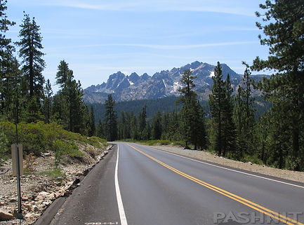
You have to experience the... North Pass
Foothill Gold...
Northeast of Sacramento is a region like that, no book or description, no pic set nor program will supply you the true sensation of the California Foothills. You have to experience it. And this tour sets off to provide you that immersion. Remember that reason you bought the motorcycle in the first place. That’s our destination. I want to go there!
But first... let’s cover some basics.
If you know anything about California and its role as the premier motorcycle destination- the reason is found in the terrain. Now, where were we? Ah yes, the ride!
This all new tour begins in Auburn, drops off the ridgeline and plunges into the Middle Fork of the American River, the goal being to check out Lake Clementine, famous for a half-circle vertical dam that creates this reservoir completed in 1939. The dam rises 155 feet above the river below and has a distinct half-moon shape that allows the water to flow over the top during spring for a spectacular display of falling water.
The elevation begins to climb as we ride into the Sierra Nevada Foothills, headed for Foresthill, the location of one of the most famous roads in the Sierra Nevada- Mosquito Ridge. However, outside of town is a fun backroad that leads over to Iowa Hill, a forgotten gold rush town that offers up a single lane road falling into the river canyon and back out.
This is Gold Rush country; after local streams & rivers were panned out, spider holes were dug into the hillsides by the hundreds. All in search of that colorful metal which was later discovered embedded in quartz rock. In Grass Valley, the Empire and North Star Mine produced 150 million dollars in gold over the course of 100 years of operation.
After WWII, the operating costs of the hard rock mines outweighed the benefit and they ceased production, however, millions of dollars of gold are said to still remain in the ground below our feet.
As the easy placer gold played out and boom became bust, miners developed easier ways than panning river banks for placer gold or burrowing into the earth, using high pressure streams of water through a nozzle called a Monitor to wash away entire mountain sides while extracting the gold from ancient gravel deposits. The result created a canyon 7000 feet wide and 600 feet deep called Malakoff Diggins. They got the gold- millions of dollars’ worth, but all the sediment & debris washed into the Yuba River System settling out in the Central Valley below.
In the late 1860s, sediment became so deep, ships could no longer navigate the rivers in the Sacramento Valley. River bottoms began to fill up with sedimentary deposits from the water monitors in the hills above. Downstream orchards, grain fields and entire towns were buried under 25 feet of mud & rivers easily flooded during spring snow melt. Wooden towns simply floated away- along with livestock, the picket fence & even the wood pile out back.
Yet water monitors worked 24 hours a day washing away mountainsides to reach the gold. Tired of the flooding, farmers organized to fight against the hydraulic mining companies. By 1880, even San Francisco Bay began to fill up with silt. Hydraulic mining ended up being the first ecological lawsuit ever filed against mining companies responsible for creating the disaster. Hydraulic mining was finally outlawed in 1884, yet the scar is still etched into the surrounding hillsides and still visible today outside the town of North Bloomfield, now a state park.
At Bridgeport, we’ll make visit to the longest single span wooden covered bridge in the world with a clear span of 210 feet over the South Yuba River. Originally built in 1862, the bridge was an important pathway to the gold fields. The design used a combination truss/arch construction and was used by auto traffic until 1972.
The route across the bridge was ultimately eclipsed by the completion of the First Transcontinental Railroad as far as Reno in 1868 via Donner Pass and traffic over the covered bridge declined. Yuba Pass climbs a mountain finger and then drops back down the other side into the South Yuba River canyon below. Then up and over San Juan Ridge to the Middle fork of the Yuba River. Next finger.
Lakes of Gold...
The elevation climbs into the Tahoe National Forest on our way to Downieville now hugging the edge of the Nork Fork of the Yuba River. South, Middle, North, we covered them all. But behave yourself, the Sheriff’s Gallows are still there in Downieville, last used in 1885 to hang convicted murderer James O’Neill. Downieville is tiny now, but at one time was the 5th largest city in all of California. It almost became the Capitol of California, losing only by one vote.
The group will ride past the towns of Alleghany, Pike City and Forest City. It has been estimated that the county as a whole produced some two hundred million dollars’ worth of gold. Of that, ninety million dollars came from the nearby Alleghany area. A few miles away is Sierra City at 4100 feet, a mere 325 people claim this as home.
In 1869, a nugget at over 1,800 troy ounces was found here. That's a gold nugget weighing 106 lbs. One might assume the gold has all played out, but a gold nugget weighing over 1,500 troy ounces was found in the Monumental Mine in 1960. That’s a 103 lb. gold nugget discovered 60 years ago.
And at the top of the range are the 8857 ft Sierra Buttes with jagged peaks dominating our view from Gold Lake Drive. With a touch of snow in the high peaks, the view is quite stunning. The Sierra Buttes include a fire lookout high atop the Sierra Range with a 100-mile view in every direction on a clear day. Accessible via a 6-mile hike with an 1800 ft elevation gain, put it on your to-do list.
This high Sierra area is known as the "Lakes Basin," a collection of some fifty lakes to the northeast of the towering Sierra Buttes. The largest of them, was named in 1850 when a miner, Thomas Stoddard, claimed he had found a mountain lake whose shores were studded with gold nuggets. The usual rush ensued; more than a thousand hopeful prospectors would set out on an expedition for this lake of gold, and repeated expeditions followed swelled by rumor and hope. Entire towns emptied as Argonauts rushed into the mountains above Downieville. No gold was ever found on those shores. The name however, Gold Lakes, remains to this day.
Hey Ma ...
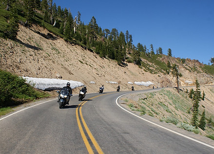
The road to get there climbs up into the High Sierra. No towns, few people, and not much of anything up here. Everyone has since gone home and left us some fantastic riding. Everyone likes a sure thing. So, if there is one thing you can bet on, it’s a Sierra Nevada mountain pass – or two, it will be an amazing ride to write home to Ma about. Hey Ma, you'll never believe where I am. The most amazing motorcycle ride ever!
The folks back home just wouldn't get it. You have to see it to believe it. If our morning started off with Yuba Pass, our afternoon rounds out with another unknown pass, La Porte Rd. Two decades ago, this was a dirt mountain jeep trail over the Sierra range.
Road crews showed up twenty years ago as if sent from Motorcycle Heaven and graded out the most amazing stretch of road- many veteran Pashnit riders call it one of the Best Motorcycle Roads in the state. That’s quite an accolade, but we implore you to come ride it and make your own judgment. If you have an irresistible urge to weep with joy once we reach the end- then you’ll know what we know.
The ride drops down Lumpkin Ridge to Lake Oroville. Completed in 1968, Oroville Dam is the tallest earthen dam located in the United States, measuring over 770 feet high and 6,920 feet across.
The dam was the largest earth-fill dam in the world until succeeded by Aswan High Dam in Egypt completed in 1970. East of Oroville, hugging the banks of the lake & after a look-alike to the Golden Gate Bridge, it's back up the hill & over the Sierra Range across the North Pass, better known as Oroville-Quincy Rd.
As the name implies, this ride connects Oroville with Quincy through the 21,000 acre Bucks Lake Wilderness. Due to heavy winter rains, the road recently fell into the canyon and has been closed the last few years, it’ll be our first chance to ride over the Sierra Nevada on this fun mountain pass in several years.
Mount Lassen...
What goes up must come down and the ride continues along the Feather River where a turn north takes us through Paradise, the scene of the 2018 Camp Fire.
Considered the deadliest and most destructive wildfire in California history burning 240 square miles and destroying 20,000 homes, businesses, churches, stores, public schools and killing 83 people. 52,000 people attempted to evacuate at the same time, and nearly the entire town of Paradise burned to the ground in six hours in an urban firestorm that spread from building to building at such a rapid rate, it was later compared to firestorms of WWII that consumed cities. The fire produced so much smoke, it spread across the United States as far as New York City. The town is rebuilding and residents are slowly returning. What leads out of Paradise is a thrilling brand-new road up to the mountain community of Butte Meadows.
About 25 years ago, I got stuck on this road in a snowbank on my Yamaha Venture. The road was dirt then. Come on the tour and I’ll tell you that story. I must have survived as 25 years later I’m now leading tours up the very same road. No longer dirt, and no longer riding a 725 lb motorcycle, it’s dreamy smooth pavement up and over the 5200 ft pass to Butte Meadows, a tiny mountain community of 40 souls. Nearby Highway 32 leads up a mountain valley to Highway 36, and a few miles away is Mount Lassen.
Twisty foothills, mountain passes, please continue.... We've got one more piece of candy to throw into the mix, our very own volcano. East of Chester, is an 10,457 ft tall cinder cone. Mt Lassen is the southernmost active volcano in the Cascade Volcanic Arc, with stretches northward all the way to southwestern British Columbia. Lassen is 'active' as in it is still steaming, bubbling and quite smelly actually. Lassen Peak has the distinction of being the only volcano in the Cascades other than Mount St. Helens to erupt during the 20th century. It is also considered the largest lava dome in the world.
On May 22, 1915, a powerful explosive eruption at Lassen Peak devastated nearby areas, and rained volcanic ash as far away as 200 miles to the east. This explosion was the most powerful in a series of eruptions during 1914 through 1917.
Smelly Mountains...
The summit receives up to 55 feet of snow each winter. Yes, that's enough snow to cover over a 5-story building. And what's the view like at the summit, one can see for miles and miles. From here riders will start parting ways and heading home. Some back to the San Francisco Bay Area, and others headed due south deeper into the heart of the Sierra Nevada mountain range to nearby Lake Tahoe or Yosemite National Park
Have a few extra days? Headed due west out to the Pacific Ocean. It's been a great weekend of riding!! A compete dose of sensory overload of mountains, lean angles and especially- the company.
Pashnit Riders from all walks of life on all types of motorcycles. All Pashnit. You'll spend much of this tour in complete and utter awe.
quick ride
Tour: TBD
Meet: 13345 Lincoln Way, Auburn
Arrive: 7:00 AM, Safety Brief 7:30, Depart 8:00 AM
Cost: $425 per rider, $109 Passenger
Tour Starts: Auburn, CA
Tour Ends: Childs Meadow, CA
ROADS: This tour includes narrow paved mountain roads. Mountain passes include steep grades and negotiating hair-pin corners. All roads on this tour are paved.
EXPERIENCED RIDERS ONLY:
This mountain tour is not recommended for beginner riders or Very Large Motorcycles. Riders are expected to have at least several years of enthusiastic experience on their motorcycle riding remote challenging paved mountain backroads along with at least 5000+ miles of concurrent recent experience...
HIGH DEMAND:
This tour is limited by the amount of rooms at our host lodging, just 10. We have booked rooms months in advance and our tours sell out by the end of January. Get on our mailing list to be the first to know about new rides. Tours are planned & announced in the late fall of each year.
Book early to ensure a spot on this new ride. Check with us to see if any available spots are open. Some of our rides may have waiting lists to be able to join the group.
MORE DETAILS: